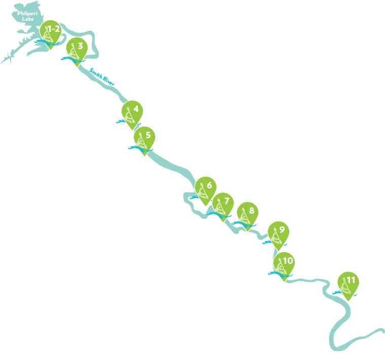
Below Philpott Dam, a 44.5-mile section of the Smith River bisects Henry County, Virginia, as it travels from Philpott Lake down to the North Carolina border. Known as the Smith River Trail System, this network includes a scenic blueway with 11 public river access points and more than 20 miles of greenway.
Travel through history as you explore the Smith River through the towns of Bassett, Stanleytown, Fieldale, Martinsville, and Ridgeway, once the heart of furniture and textiles in America. Explore the rock outcrops, rapids, scenery, and Native American fish weirs still intact on sections of the river.
Our Future Plan
Curious about what the future holds for our trail system, check out our 2019 Rivers & Trails Recreational Use Plan
Smith River Trail System
Download a detailed version of our Trail System.
Smith River Blueway
Visit Smith River Blueway to discover more or see below to download a printable detailed version of our trail system!
Along the Smith River Blueway, eleven public canoe ramps are available for use by paddlers and fishermen. If you enjoy whitewater, canoe or kayak the river during peak generation from Philpott Dam. If a relaxing flat water paddle is more your speed, put your boat or tube in further downstream.
Travel time is determined by water level and flow conditions; hydro-electric generation will increase water flows and decrease travel times. A general rule of thumb for planning canoe or kayak trips on gentle moving water is to allow 25-30 minutes per river mile. Call 276.629.2432 before paddling or fishing to listen to a recorded generation schedule for Philpott Dam. Scroll down for River Safety tips.
River Access

1-2. Philpott Dam Access (6.4 miles to next access)
Another access is located on the opposite side of the river in Franklin County
View Current River Conditions near Philpott
3. Bassett River Access (4 miles to next access)
View Current River Conditions in Bassett
4. The Great Road River Access (4 miles to next access)
5. Fieldale River Access (5.2 miles to next access)
6. Doe Run River Access (Portage required to navigate around Martinsville Dam)
7. South Martinsville River Access (4.5 miles to next access, shorter option available*)
View Current River Conditions in Martinsville
8. Frith Drive Access (3 miles to next access)
9. Monogram Foods Smith River Sports Complex River Access (2.2 miles to next access)
10. Marrowbone Creek River Access (3.4 miles to next access)
11. Mitchell Bridge River Access (12.8 miles to Spray Dam in Eden, NC)
River Safety
- All boaters should wear a coast guard approved PFD (life jacket) when on the river.
- Paddle with others if possible.
- Carry a spare paddle.
- When paddling in the wind, stay close to the shore.
- Use caution when launching or landing on slippery rocks or muddy areas.
- If you capsize, stay calm. Hold onto the boat and paddle and move to shallow water.
- Do not attempt to stand up in moving water deeper than knee deep.

